Saturday, February 28, 2015

RUNGE NATURE CENTER, JEFFERSON CITY,MO

Nature centers are organizations designed to educate people about nature and environment.
Compared to state parks they have only few acres of land. Nature centers can be seen through
out  in all states of USA. Most nature centers have a visitor center or interpretive center to help the visitors .
Runge Nature and conservation center is one among the  32 nature centers in Missouri. This center is
  located in the heart of Jefferson city, the capital of "show me state" (Missouri).
It  provides awareness about the nature and wildlife of Missouri.
The visitor center has a well designed museum with a cool display of wild life , which attract people
 of all ages .Facilities at the center include a small auditorium, library, reading room and a  small
theatre which  plays nature movies .
 
At the entrance of this informative  and fun filled nature center, there is a giant sculpture of a 
captivating and whimsical  frog sitting on a lotus leaf. Runge also attracts the kids with its  nature
  related displays, reptiles, live snakes and the 2400 gallon fish aquarium with indigenous fishes.
They also have a good   collection of stuffed specimens of rabbit, squirrels,  birds and other native 
 animals . Several bird feeders are placed at the outdoor viewing area,  which overlook the woods at
 conservation center .A big horizontal tree slice with clear growth rings is also displayed here.
This 100-acre area in Jefferson City also features special events, trails, demonstrations, and diverse
 natural habitats. This   is a great place to visit and explore the nature in close proximity .
With  beautiful woods and well marked natural trails  the center provide visitors hands-on
opportunities to  understand and appreciate the natural resources. From the five paved hiking
 trails,  you can chose  the best depending on your time.
The trails have plenty of benches to rest along the way. Deer's , squirrels ,frog, butterflies and wild
birds like  great blue herons, red cardinals and turkeys can came across your  path at any time.

The Runge Conservation Nature Center in Jefferson City annually  conduct native plant sale with the
  idea of landscaping with native plant species. The idea behind this is to provide an urban habitat  for
a diversity of wildlife. Many varieties of wild plants, flowers  and trees can be seen along the trails .
Runge is also home to  White tailed North American deer  buck (male),  does (female)
and  fawn( young ones) . The name  Buck  came from the American Frontier  when the skin
 of a Male Deer was  worth one dollar or buck. Antlers ( extension of skull) are  the fastest growing
 tissue on earth and deer's are the only animal with antlers on earth.

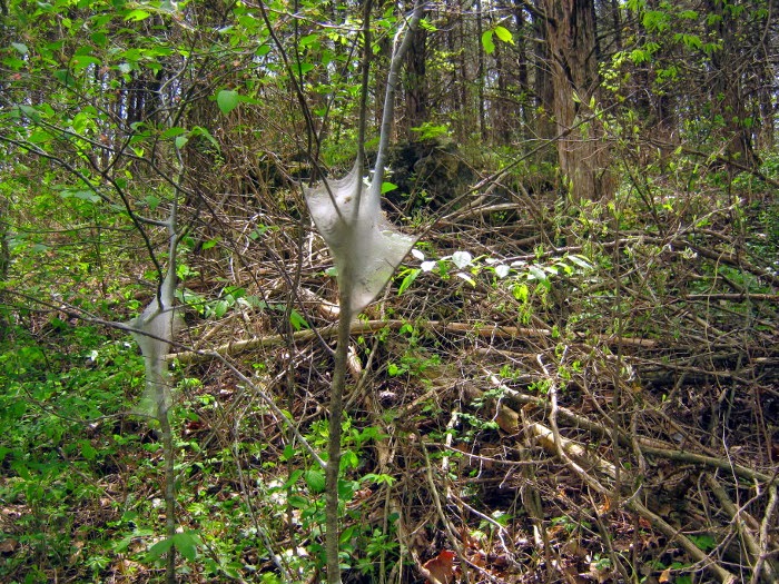
 Eastern Tent caterpillar or Army caterpillar is a blue and yellow spotted caterpillars which are the
larvae of snout moth. This social species form communal nest on the branches of trees . Many of
their nests can be seen along the trails. This caterpillar is said to be toxic to horses.
Aromatic wild  violet flowers seen at Runge conservation center is a heart shaped purple flower
 used in cooking as well as in  medicine for thousands of years. They are planted in garden in a
controlled way. They are also considered as weed because of their  waxy leaves , extensive root
system  and resistance to weed killers.

Falls Aster with a blue tint and narrow leaves, also  known as white dolls daisy is seen abundant  at
the center. This attractive wild flower, native to US and Canada, is found on moist, sandy flood plains
 and prairie wetlands.

The fluorescent  flower clusters of North American red bud cauliflory trees ,comes directly  out of
tree trunk. This is a beautiful sight at the nature  center during spring .Cauliflory is a term used to
 describe the production of flowers on the trunk and branches of woody plants.
  Fall foliage makes autumn  the most vibrant time of a year. It  turns oak leaves to red or brown,
hickory to bronze, aspen to gold , dog wood leaves to mix of purple and red,  red maple leaves to
 scarlet, sugar maple to orange red  and black maple to bright yellow. Sunset add a  colorful
 splendor to the trees and surrounding areas during the fall.

Historical fire tower is a proud symbol of forest conservation in United States. It gives housing and
protection to the employee who search and protect the area  from  wildfire and wilderness Fire towers

now have  a backseat to new technology. From the fire observation tower at the conservation center
 one could enjoy the panoramic  view of the region.

There are many events and  programs going on at the center for children of all ages as well as adults.
  Free   brochures along with bi-monthly newsletter  Habitat Happenings about the happening and
activities  at Runge Conservation center can be collected from  the main building.


Note: Building hours are 8 a.m. to 5 p.m., Tuesday through Saturday with extended hours until 8 p.m. on Thursdays. The building is closed on Sunday and Monday. The outdoor trails are open from 6 a.m. to 9 p.m. daily.
 
 
Note: Cameras Used :-Canon Power shot A490, Canon Power Shot SD 400
 
Location: Missouri 179
                Jefferson City, MO 65109.
                573 526 5544


Friday, February 13, 2015

ROYAL GORGE COLORADO

Royal Gorge also known as Grand canyon of Arkansas  is located south of Denver, the capital city of
Colorado, USA .Canon City is the gateway to the Royal Gorge region, Colorado's most popular
tourist area. The name Colorado is  of Spanish origin, meaning "colored red "which  was originally
applied to the Colorado river by Spanish people because of the red sandstone soil of the region.
Colorado has 25 nationally designated Scenic & Historic Byways, and a number of mind-blowing
drives. The region has a  diverse geography, ranging from alpine mountains, arid plains, deserts with
huge sand dunes, deep canyons, sandstone and granite rock formations, rivers, lakes, and lush forests.
Many of the sceneries that are photographed in this colorful state looks like an oil painting  by mother
 earth. Colorado is the only state in USA that entirely lies 1000 meters above sea level. The mountain
 range of southern Rocky mountains called Front Range covers Western Colorado while eastern
 Colorado is a part of the Great Plains . The Continental Divide runs north-south along the Rocky
 Mountains in Colorado.
Lt Zebulon M Pike, whose name adorns Pike's Peak, and his men were the first American explorers
to view this Arkansas river canyon  now known as Royal gorge in the year 1806. Royal Gorge  park
 is  situated at an elevation of 6626 feet.This scenic and dramatic area  has a place in the National
Register of historic places.
It is said that about 3 million years ago as the Rocky Mountains rose from the surrounding plains,
 a  small rivulet that would become the Arkansas River rose with them. Over the millennia, it cut a
deep channel for itself through the surrounding granite, at a rate of about one foot every 2,500 years!
The Gorge began to form  when trickles of water slowly began to carve a  canyon out of the solid
granite bedrock of the Rocky Mountains. Geologists believe that this  deep and unusually narrow
 canyon  has been formed by the incessant grinding of pebbles and sand grains against the river bed
as they are carried along by the stream. The gorge's peculiar shape, contrasted to broad canyons
such  as the Grand Canyon, can be attributed to this long, direct erosion through hard rock. 
 Royal Gorge Bridge is a one-lane wood-decked bridge with more than a quarter-mile (1260ft) length
 and  hangs 1,053 feet above the Arkansas River .This engineering feat constructed in 1929 is one of
the highest suspension bridges  in  the world and is owned by the City of Canon City .
 The bridge  sways in the wind along with  the flags of every states attached to it. Royal Gorge 
 Bridge  is 880 feet  high and 18 feet wide and is suspended from towers that are 150 feet high. 
One can walk or take a Segway tour, bike tour or a bus to cover the park. 
 Constructed in 1931, The Royal Gorge Incline Railway is one of the world's steepest railways.  This
is a standing only railway that goes straight down the cliff  at a 45 degree angle
The inclined track is a 3ft narrow gauge funicular railway  and the ride is offered in  small red  cages.
 It drops you to 1550 feet  to the bottom of the gorge in just  5.5 minute .
 Originating from  Rocky mountain, Arkansas river is a major tributary of Mississippi river. From the
 source Lake Itasca, it passes through 10 states and reaches the mouth at Gulf of Mexico. One can
 also climb aboard  Royal  Gorge Railroad to experience the scenic train journey through this
 spectacular Royal Gorge. Once at the bottom, you can walk along a fenced walkway, by the river .
The  Arkansas river offers a wide variety of activities like fishing, white water rafting and kayaking.
 From the bottom you can look up at the bridge, high above you and will see Royal Gorge Bridge so
 tiny from below and can’t even see the people or cars crossing it.The natural beauty of the Arkansas
 river gorge is spectacular beyond any doubt.
 Royal Gorge has one of the world's scariest sky coaster. Those who want world class thrill and 
experience can try  this. Royal Rush Sky coaster sits on the very edge of the gorge, hoist guests up a
 100 ft tower and let them swing  over a thousand feet in the air in a superman style with nothing
attached to them but a thin cable.This  free-fall sweep with a speed of 50 mph, hang you momentarily
  over 1,200 feet above the Arkansas River.( not recommended for heart patients ).They also have an
 Aerial Tram that takes you across the gorge.
Another adventure is the Soaring Eagle Zipline, the world's highest Zipline. The  Eagle flies more
than 1,000 feet above the Arkansas River at 25 miles per hour. Thrill-seekers are strapped into seats,
leaving their arms and legs frighteningly free. The ride consists of two zip lines carrying two riders
each, and will zip 700 feet over canyon walls from 1,000 to 800 feet above the Arkansas River, and
then zip back at approximately 30 miles per hour.( not recommended for heart patients).( no photo)
Royal Gorge Park also has a few assorted  animals .This wildlife park has a small herd of buffalo,
elk, bison and bighorn sheep.  All the animals miraculously survived the fire that swept through the
 park in 2013 . A rare white buffalo named smoky was born in the park after this wild fire .
  Big Horn Sheep is a species of sheep found in North  America. Bighorn sheep got their name from
the large, curved horns on the males, or rams. Their  horns can weigh up to 30 lb (14 kg), while the
sheep themselves weigh up to 300 lb (140 kg). They are legendary for their ability to climb high,
steep and rocky mountain areas.
Female big horn sheep known as Ewes also have horns but small with a slight curvature. In the fall,
the rams compete for ewes by having butting contests. They charge each other at speeds of more than
 20 mph, their foreheads crashing with a crack can be heard more than a mile away. These battles
 may last as long as 24 hours.
Rocky Mountain bighorn sheep is the state animal of Colorado from 1961 onwards  and as such is
incorporated into the symbol for the Colorado Division of Parks and Wildlife.
 Bison's are the heaviest land animals in North America  (1600kg) and can run 40 miles an hour. This
symbolic  animals of the Great Plains, are often mistakenly called buffaloes. Millions of  this 
formidable beasts once thundered across North America .Habitat loss and unregulated shooting
reduced the population to just 1,091 by 1889. Today, approximately 500,000 bison live across North
 America. The calves weigh 40 to 50 pounds at birth.
A wild fire broke out in the park on June 2013 which caused severe damage to many world class
attractions including  48 (out of 52 )buildings,3218 acres of land ,visitor center, Aerial tram and some
 damage to the Incline railway. The famous Royal Gorge Bridge suffered minor damage; only 32 of
the planks on the deck were burned .No animals in the park suffered any injury and all survived.
 
Demolition took almost 5 months and the park is seeking a come back through various measures .
 The park is now open for bridge-only guided tours on weekends.  Visitors can still enjoy the Royal
 Gorge via the Royal Gorge Route Railroad, which remains open.. The park is on the track to open
 more buildings and attractions by spring 2015.
 
 
Note: Cameras Used :-Canon Power shot A490, Canon Power Shot SD 400
 
Location From : Denver, Colorado- 127 miles (2.30hr drive)
                           Colorado Springs- 58 miles (1.27hrs drive)
                           Pubelo, Colorado- 53 miles (1.8hrs drive)
 

Wednesday, February 4, 2015

ROHTANG PASS , HIMALAYA

Sometimes journey is better than the destination. This post  is about such a beautiful and eventful
  journey to Rohtang Pass, a landslide-prone area  situated in the  Leh- Manali highway. Opened only 
for about four and a half months in a year in summer, this 298 mile highway is designed, built and
  maintained entirely by the Border Roads Organization (BRO) of Indian army. Starting from Manali,
 this strategic military route ends at Leh, a district in the Indian state of Jammu and Kashmir. In
ancient time, Leh was an important   stopover on trade routes along the Indus valley between Tibet to
 the  east, Kashmir to the west and also between India and China for centuries .
This  Journey  starts from Manali, a beautiful Hill station located in the northern end of Kulu valley,
 Himachal Pradesh, India.Roads in Manali are lovely and beautiful with heavily laden branches of
Apple trees on both sides. Serenity of Manali is often disturbed by the sounds of  twittering birds and
 gushing waters flowing through several creeks on roadsides. Eucalyptus trees, towering coniferous
trees, sweet scented  apple trees and  divine Devadaru (Deodar) trees can be seen  on the roadsides
  swaying  and whispering with  the pleasant mountain  breeze.
Rohtang Pass is situated in the eastern Pir Panjal range, the largest range of lower Himalayas.
In olden days, people from northern side of Rohtang Pass tried to cross the pass to discover the
other side. The road trip to Rohtang pass itself  is amazingly beautiful, scenic, adventurous and
eventful than  reaching  it. It took almost 3-4 hours from Manali to reach the destination..
 The road to this mountain pass is really horrible with frequent traffic jams and long queue of
vehicles . Starting early can only  help you to reach the destination on time. One can also hire a taxi
 from Manali with experienced  Sherpa  drivers to guide you in this adventurous journey. Sherpas are
  elite mountaineers and expert  drivers  from mountainous Nepal.
Manalis’s peace and serenity along with the mind-blowing sceneries can make you feel like
  travelling through a paradise on earth . People here mainly depend on agriculture for their
  livelihood.  Many people derive their income from sheep, goats, and other cattle. Large flocks of
sheep and goat may often block your way and many times you feel to jump out of the car to
 capture these beautiful moments of  village life.

Trekking and travelling through this most spectacular and picturesque landscape in the world is one
 of the  beautiful experience that can be cherished in the entire life. Besides the Greater Himalayas
( highest and northern most section of the Himalayan mountain ranges), there are several parallel
lower ranges of Himalaya. The southernmost of these, located along the  northern  edge of the Indian
plains and reaching about a thousand meters in altitude, are called the Sivalik Hills and  further north
is a higher range, reaching two to three thousand meters is known as the Lower  Himalayan Range.
Rohtang Pass lies in the Pir Panjal range ,which is group of mountains in the Inner Himalayan region.

Rohtang Pass remains snow bound in winter for over six months. Based on snowfall , it opens from
 May to November only. Rest of the time it is difficult to cross due to snow storms and avalanche.
This  high mountain pass also known as gateway to Leh Ladakh, is situated at an elevation of 3,979
m (13,054 ft) above  the sea level.The twin peaks of Geypan is also visible from Rohtang.The pass is
situated on the watershed between the water basins of the Chenab River and the Beas River.
The winding road through the high mountains with snow cap and lush green valleys is really a
spectacular view .The spiral road going up is really awesome and feels ecstatic the higher you go.
 Mount Everest, the highest peak in the world  is located in  a section of  the Himalaya .
 The highway crosses many small streams of ice-cold water from snow-capped mountains and glacial
 melts. Glaciers melting alongside makes the road  wet and slippery  which requires  good driving
skill to negotiate the fast-flowing streams. A Glacier is a large mass of  dense ice formed over many
years and does not melt during the summer.The  Himalayan range  is a great source of fresh water
 and encompasses about 15,000 glaciers . The major Himalayan Glaciers in India include Gangothri
(origin of river Ganga), Yamunothri ( origin of river Yamuna), Siachin, Khumbu, Lantang etc .
The word India is derived from the Indus  river also known as Sindhu. Indus river originate from
Tibet in the  vicinity of lake Manasarovar in the Himalaya . The major cities of the Indus Valley
Civilization such  as Harappa and Mohenjo-Daro dates back to 3300 BC, and  representing some of
the largest human habitations of the  ancient  world  was flourished on the banks of river Indus. Other
 than the Indus, major rivers originating from the  Himalaya are Brahmaputra, Jhelum( Vitasta), Spiti,
Chenab ( Chandrabagh), Sutlej  (Satadru), Ravi (Iravati), Beas (Vyas/Bipasaha) ,Ganga and Yamuna.
Rohtang  pass lies at an altitude of 13,054 ft or 3,980m, is one of the highest mountain passes in the
 world. Since before recorded history mountain passes played a key role in trade, war and migration.
As you progress the greenery disappears and the mountain slopes become more brown  and  arid.
But you can still see at a distance the beautiful sight of glaciers, and snow covered mountain peaks.

The Himalayan road is narrow, bumpy and damaged at many location. The drive to the pass is really
scary and one will start experiencing the true roughness of the Himalayas. The highway has many
damaged stretches and under-maintenance portions .The riding quality is not good at many places and
 utter care is required when there is fog and the road  is invisible and slippery. Awesome and breath-
catching trip through this pass is a real combo of beauty and danger.

There can be unpredictable occurrence of snow storms, rain and high winds in this journey. A  little
rainfall can trigger landslide making it very dangerous to cross the stretch of  road. The Manali-
Keylong/Leh highway which leads to the amazing Leh-Ladakh  has seriously narrow and sharp hair
 pin turns which make you really scary and can cause  adrenalin rushes, till you reach the pass .

Several episodes of the History Channel's Ice Road Truckers series spinoff IRT Deadliest Roads
dealt with truckers crossing the Rohtang Pass to deliver supplies. IRT is a reality television series
premiered on History channel  in which truckers battle some of the harshest conditions on Earth to
get their cargo where it needs  through the most dangerous routes in the world.

Those who want a thrilling and adventurous ride can opt for a Mountain ATV ( All Terrain
vehicle) at  Rohtang.  Motor bike tour is another adventurous safari which crosses over high
mountain passes, providing spectacular views of the snow capped peaks and rugged terrain .
One can also indulge in activities like  skiing, sledding or can ride a snow scooter at Rohtang pass.

 Paragliding has been one of the most popular tourist attractions at Rohtang . Paragliding is subject to
 wind conditions  and is recommended only for adventure seekers. Soaring in the sky  and riding with
the wind and clouds  assure a panoramic view of the valley and the surrounding mountains .

This place is  a vast land covered in snow. The oxygen content is low and you cannot walk more
than 100-200m in a go. But the scenery and not-even-thought-of surprises along the highway in
this  picturesque landscape of endless mountain ranges is enough to makes one enthralled.

Mount Kailas of Himalaya is considered as the abode of Hindu God Shiva and his family. Parvathy
Devi ,the wife of Lord Shiva, is considered as the daughter of Parvat (personification of Himalaya)
  and hence called Parvathy. The Sanskrit poetry Kumarasambhavam by the ancient classical poet
 Kalidasa ( believed to be lived  in 5th century AD) starts with a canto praising the Himalaya
Mountain. (Astyuttarasyāṁ diśi devatātmā himālayo nāma nagādhirājaḥ |pūrvāparau toyanidhī
vigāhya sthitaḥ pṛthivyā iva mānadaṇḍaḥ) . This sloka praises Himalaya as the king of all mountains
who stand at the northern frontier and stretches between oceans on east and west to border the heartland of gods .
As per the Indian epics, in those days, mountains are said to  have wings and they could fly. In the
 process the rishis and sages meditating  on the mountains were at a risk of falling off. So Lord  Indra
 began to  cut the wings of mountains. The wind God (Vayu Deva), the father of Hanuman rescued
  Mynaka mountain, the son of  Himalaya  and hid him under the sea. As a gratitude Mynak hiding
 under the sea rises from sea to provide a rest stop to  Hanuman on his way to Lanka in search of
 Sita Devi, the wife of Rama, kidnapped by the asura king Ravanan  ( Ramayana).
Himalya is a Sanskrit word which means abode of snow. This youngest mountain range mainly
 consist of sedimentary and metamorphic rocks. The Himalaya played a prominent role in shaping the
 culture of south -east Asia and is a source of many major rivers. As per modern theory, Himalaya
is formed as a result of continental collision between Indo- Australian plate and Eurasian Plate. After
Arctic and Antarctica ,Himalayas have the third largest deposit  of ice and snow in the world .

The road often collapses at many parts which make tourist vehicles, supply trucks and military
vehicles gushing one behind the other trying to  navigate through tight roads. The rough terrain
 compounded by slippery roads and snow make long and heavy traffic jams. Nearly 87.3% vehicles
 reaching Rohtang Pass belong to tourists while 8% vehicles belong to Army, including private trucks
 on supply. These trucks are on duty for the Army and military establishments in Ladakh -Leh region
of Jammu and Kashmir along the China and Pakistan border .Rohtang tunnel ,an all-weather alternate
 route is under construction by BRO, which reduce the travel distance between Manali and Keylong.

Rohtang Pass is a busy military and tourist road and military convoy will always come from opposite
side . The Pass is also  frequented by  adventure seeking people to experience  the snow laden peaks,
crystal glaciers , rivers and magical mountains of great heights. This journey is an unbelievable
combo of beauty and danger, one  can only see with their eyes to believe. With many surprises this
 trip gives you  best and closest view of the Himalayas and once you make it to the top you will forget anything.


Note: Before going to this place you have to get necessary permissions and also don't forget to make
 special packing ( food, necessary clothing ,medicine etc.).


By Road : From Manali , Himachal Pradesh- 50 km
Time required ( can vary ): between 4-5 hrs
.