Wednesday, January 13, 2016

LOWER GEYSER BASIN , YELLOWSTONE NATIONAL PARK

Geyser is a geological feature in which a spring is characterized by intermittent discharge of water
 ejected turbulently, accompanied by steam. Geysers are usually found near active volcanic areas
where there is proximity of magma. Intense heat, water and plumbing system are the three ingredients
for a geyser. Geysers occur when water passes through fissures and cracks on earth surface and
 contact with the hot rocks at a depth of 6600 ft and get boiled. Boiling of the pressurized water result
 in the geyser effect of hot water and steam ejecting out through the vent on geyser surface . 
Geysers can be classified as Cone geyser and Fountain geyser. Cone geyser erupts from mound of
volcanic rock (siliceous sinter or geyserite ) and erupt in steady jets. While fountain geyser erupts
from  pools of water in a series of intense or violent burst. Geysers only  persist  in places where
volcanic rhyolite rock dissolves in hot water and form mineral deposit (siliceous sinter or geyserite)
inside the  slender  plumbing system of the vent. The minerals thickens the inner walls of the cracks. The specific colors of geysers can be attributed to micro living organisms which thrive in extreme weather conditions.
Geysers exist only in few places in the world and Yellowstone has the highest concentration of it.
  Valley of Geysers in Russia have the second largest geyser concentration in the world and it is the
only place in Eurasia having geyser. El tatio Chile, Taupo Volcanic zone Newzealand  and Iceland
are the other places in the world where one can see geysers. Geysers found in solar  system are
known as Cyrogeysers and the ejections from such geysers are mainly nitrogen and carbon dioxide.
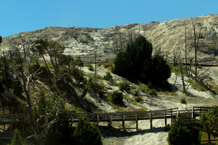
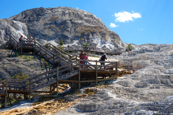
Lower Geyser basin is the largest geyser area in Yellowstone. It extend over 12 sq miles and is 
located north of upper and midway geyser basin on the grand loop road . Lower basin posses a large
 variety of  thermal features like mud pots, geysers, pools, springs and fumaroles. The .5 mile
 Fountain Paint pot trail gets visitors up close to attractions like Great Fountain  geyser, Silex spring,
 Celestine Spring, Fountain Paint pot, Leather Pool Morning Geyser, Jet Geyser, Clepsydra Geyser  and Red Sprouter.

Thermal features of Lower Geyser Basin are scattered and fall under several groups like Fountain
group, Kaleidoscope group, Fire hole Lake group, White dome group, White creek group, Black
warrior  group, Sprinkler group, thud group , Imperial Group and so on. All geysers seen here
belongs  to any of these group. 
Great fountain geyser  is the only predicted geyser in the lower basin. Located in the Firehole lake
area of Lower geyser basin, Great Fountain Geyser erupts every 9 -15 hrs up to a height of 23 to 67
mts. Sometimes it also exhibit  a wild phase behavior pattern which make it sometimes unpredictable.
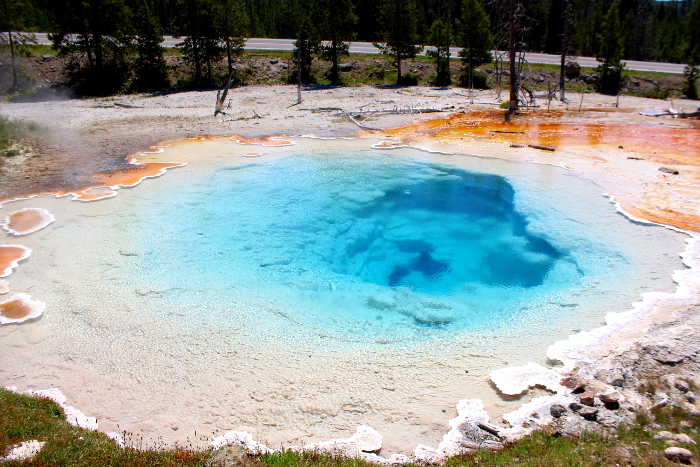
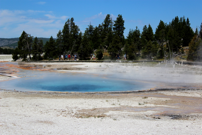
Silex Spring is a blue pool rimmed with white silica. Silex is a Latin word meaning silica , a major 
component of rhyolite, the volcanic rock found abundantly  at Yellowstone. The water here is too hot
 which is evident by the blue color of the pool . Thermophiles which survive this hot water is seen in 
yellow color on the rippling runoff water surrounding the pool. The orange color seen here  is due to 
the presence of these heat loving bacteria.
A deep blue color pool called celestine pool can be seen here. Beside it is another pool called Leather
pool, that  resemble  leather due to the thick mats of brown thermophile. The pool lost its brown color
after the1959 earthquake that created  high temperature and killed all its bacteria. 
Morning Geyser is a seldom active but one of  the largest geyser in the Fountain area and one of the 
largest geysers in the world. Its last period of activity longed for one week in 1994. Twig Geyser is
 another major geyser and first of the regularly erupting geysers on this trail. Jet Geyser  plays in the
 hours leading up to an eruption from Fountain Geyser while Spasm is a small geyser right next to
 the boardwalk. Sizzler is a small geyser and erupted  from a cracks in the sinter. More recently it has
 started forming a crater
Bacteria Mats is another interesting feature at Lower Basin. Here a vast area is seen in thick colors
 which means the presence of thermophiles. The green , brown orange colors are due to the activity
of cynobacteria which can survive in 167 degree F.  They become yellow or green at hot temperature
 but become orange, rust or brown colored when water cools. Colors can also vary due to stress such
 as  intense sunlight of midsummer. 
Fountain Paint Pot is a type of thermal feature called a mud pot or mud volcano . It  has the odor of
 rotten eggs due to the presence of hydrogen sulfide gas. The acid and microorganisms dissolve the
 rocks  into clay and mud. Mud pots usually appear in white or grey but also appear in red or pink
  due to the presence of iron oxides and minerals. Mud pot is a natural double boiler. In early summer
they are thin and watery and become thick by late summers. The mud is composed of clay minerals
 and fine particles of silica. Rocks found here is rhyolite composed primarily of quartz and feldspar.
Acid in the steam and water breakdown feldspar into a clay mineral called Kaolinite .
Red Sproutter is another attraction at Yellowstone. The 1959 Hebgen lake earthquake, which was one
 of the strongest and deadliest earthquake in history, created many new geysers and cracks in
Yellowstone  National Park  including the Red Sproutter. It exhibit the behavior of geyser, fumarole,
 hot spring and mud pot. During early summer its pool splashes red colored muddy water and in late
 summer and  fall it changes into a hissing fumarole.  
Lodge pole pine is the common variety of trees find in Yellowstone. A group of Lodge pole pine 
trees seen at Lower basin are pioneers that did not survive.  Silica presence in the basin  has 
penetrated the trees and hardened their base which slowed their decomposition.
There are many dormant geysers in Lower geyser basin which take our attention only when it is
active.  Jelly Geyser erupts in a range of 10 mts to more than an hour and last for less than a
minute. Clepsydra ,meaning water clock in Greek,  is another geyser which erupts to a height of 45 ft.
 It was a predictable geyser which erupted every three minutes before the earthquake of 1959. Lower
Geyser Basin is one such area  where one can witness all kinds of thermal features in one area
 including active geyser, dormant geyser, pools, mud pots and fumaroles.


Camera : Canon t5


Sunday, December 13, 2015

TOWER FALLS AND GRAND CANYON YELLOWSTONE NATIONAL PARK

Yellowstone's main road is the Grand Loop road which serpentine's 142 miles around Yellowstone
 like an inscribed circle on the very heart of the park. This loop connects visitors to every classic gem,
 from  Mammoth Hot Springs near the North Entrance to Fountain Pots and Old Faithful near the
 West and South Entrances.  The scenic drive  offers splendid view of rivers, waterfalls, meadows,
 forests, cliffs, canyons, geysers and a myriad of wildlife 
Grand Loop road is a  primary road system in the Yellowstone National Park that covers 140-mile
 (230 km) . The road was  originally planned by Captain Hiram  Chittenden  of the US Army Corps
 of Engineers in the early  days of the park, when it was under military administration. It provide 
access to the  major geothermal areas of the park, including the Upper, Midway and Lower Geyser
 Basins, Mammoth Hot springs, Tower Fall, Grand Canyon of the Yellow Stone and lake Yellow Stone
On grand loop road,  Columnar basalt cliffs  formations overhangs the road  at Junction Butte Basalt .
Basalt is a  common extrusive igneous or volcanic rock formed from the rapid cooling  of basaltic 
lava exposed at or very near the surface of a planet or moon. It is less than 20% quartz and  less than 
10% feldspathoid by volume, and where at least 65% of the feldspar ( mineral with the   presence of 
alumina and silica ) is in the form of plagioclase.
Columnar Basalt flows formations can also be seen while approaching the Tower falls. Basalt is one 
of the most common rock types in the world . It is used in construction ( building blocks ) making
 cobblestones for road pavements, (from columnar basalt) and in making statues. Heating and 
extruding basalt yields stone wool, which is said to be an excellent thermal insulator.
Tower Fall is a waterfall on Tower Creek on the northeastern region of Yellowstone National Park. 
It is located in the Tower- Roosevelt section of the Grand Loop Road at Yellowstone.This scenic 
waterfall with an impressive 132 foot drop is surrounded by vibrant green moss . A paved pathway
 with signboards takes you from Tower falls store area to an overlook point  and provides a 
perspective view of the falls. The overlook point is  approximately 300 ft above the yellow stone river.
Tower Fall was originally called as Little falls by fur trappers.  This chastely beautiful water falls was
 renamed as Tower falls by one of the members of  Wash burn party in 1870 due to the tower shaped
 pinnacles ( volcanic rocks) surrounding it. Almond Gunnison in 1883  wrote  " Great towers, shapely
 as cathedral spires, rise on either side with slender fingers like the minarets of a mosque strangely
 colored forming a royal setting for the water which from 200 ft above falls into a the boiling chasm.
 Surroundings are much like Minnehaha falls only here is greater majesty".
The Canyon Village area of Yellowstone is one of the most majestic areas found within the Park 
boundaries.Canyon Village is located  in the center of the park. Three roads lead to Canyon: Norris is
 12 miles to the west; Tower Falls is 19 miles to the north; and Lake Village/Fishing Bridge is 16
 miles to the south. Canyon Village is a base camp for exploring the Grand Canyon of the 
Yellowstone River, one of the most popular features in Yellowstone National Park.
The canyon offers several hiking trails ranging from easy to strenuous . Uncle Tom's trail having 300
 steps takes 500 ft down to the canyon from where Lower fall is clearly visible. South Rim trail 
stretches to 3.2 miles takes you to two view points of the  Upper falls ( 109 ft down) from where Old 
Canyon Bridge is also visible. From the left overlook a glimpse of Crystal falls is also visible.
 Another trail which begins at the Grand view parking area is  the half mile  Grand view Loop trail.
 South Rim is a partially paved trail which begins at Wapiti Lake trail head on South Rim Drive near 
Chittenden Bridge. It run parallel and connect the Wapiti lake trial head with Uncle Tom's Point and
Artist Point ( 1.75 miles or 2.8 km). The trail offers striking viewpoints of both falls and canyon

 North Rim trail takes you to the brink of Lower Falls. Depending on the weather 5,000 to 60,000
 gallons of water plunges from a height of 308 ft to yellow stone river. North Rim trails drops to 600
ft and it is not recommended for people with poor health conditions. Another major trail is Red Rock
trail which  drops to 500 ft and  takes the hardy visitor closer to lower falls . The canyon was a barrier
to early  travel, but became a destination for visitors when roads made the park more accessible. 
The Grand Canyon of the Yellowstone is roughly 20 miles long, measured from the Upper Falls to
 the Tower Fall area.This unique natural treasure has a depth of 1200 feet  and 1500 to 4000 ft width.
 Upper and Lower Falls of the Yellowstone River add to the grandeur and make it looks like a 
enormously painted mural. Upper falls viewpoint, Artist point (one of the most photographed view 
points), Look out point, Red Rock Point,  Grand View point  and Inspiration Point  are view points
 which offers a spectacular view of the Grand canyon. Puffs of steam mark the hydro thermal feature 
in the canyon walls and the  streaking hues along the canyon walls are surreal.
The Upper Falls is upstream of the Lower Falls and is 109 ft. high. It can be seen from the Brink of 
the Upper Falls Trail and from Uncle Tom's Trail. The Lower Falls is 308 ft. high and can be seen 
from Lookout Point, Red Rock Point, Artist Point, Brink of the Lower Falls Trail, and from various
 points on the South Rim Trail. Lower falls is also known as Great fall or Grand falls of Yellowstone.
The Lower Falls is often described as being more than twice the size of Niagara, although this only 
refers to its height and not the volume of water flowing over it. The volume of water flowing over the
 falls can vary from 63,500 gal/sec at peak runoff to 5,000 gal/sec in the fall.
A third falls is located at the canyon between the Upper and Lower falls. Crystal Falls is the outfall
of  Cascade Creek into the canyon. It can be seen from the South Rim Trail just east of the Uncle
Tom's  area. This silky 130 ft water falls bounds through pine trees towards the Yellowstone river.
The Yellowstone river snakes through the  canyon  as it rushes downstream which also cause erosion
when flowing through soft  and less resistant  rocks thus increasing the depth and width of the
canyon .Yellowstone river is a tributary of Missouri river with a length of 692 miles and the largest
high altitude mountainous river in North America.
 Yellowstone river rises in northwestern Wyoming in the Absaroka Range. It is the largest and major
rivers at Yellowstone National Park, though its origin is outside the park. It is also the longest
undammed river in the contiguous North America and thus retain the natural habitat characteristics
and flows. The other major rivers at Yellowstone are Bechler, Firehole, Gallatin, Gardner, Gibbon,
Lamar, Lewis, Madison and Snake river.
Yellowstone’s Grand Canyon is not as big as the Grand Canyon in Arizona, but the beauty and
grandeur is nonetheless breathtaking. The present canyon is estimated to be 10,000 to 14,000 years
old. This recent geologic feature is believed to be the result of erosion rather than glaciation. The
canyon village complex is a part of the Mission 66 project in the park. The Visitor center which
opened in 1957 is also located 1/8 mile southeast of Canyon Junction in the Canyon Village complex.

Friday, November 13, 2015

UPPER TERRACE OR MAMMOTH HOT SPRING- YELLOWSTONE NATIONAL PARK

Mammoth Hot Springs is a large complex of hot springs on a hill of travertine ( limestone deposit)
at Yellow Stone National Park . It is one of the world's best examples of travertine-depositing hot 
springs. Limestone is the dominant underlying rock here instead of rhyolite (silica rich rock), which
 is dominant in park's other major  hydrothermal areas. This hotspring is located adjacent to Fort
Yellowstone and  Mammoth Hot springs Historic district. Fort Yellowstone was established for
military purpose while Yellowstone park was under the control of military during 1886-1918. 

Mammoth Hot Spring also known as White Mountain hot spring lies outside the caldera boundary.
 This natural sculpture  was created over thousands of years as  hot water from the  spring cooled
and  deposited  calcium carbonate on the surface. When hot water rises through limestone, large
quantities of rock get dissolved and a white chalky mineral is deposited on the surface. Mammoth hot
 spring gets its energy from the same magmatic system that fuels other Yellowstone geothermal areas.
The entrance to the Upper Terrace Drive is two miles (3.2 km) south of  the Albright Visitor Center
on the Grand Loop Road.  This road  provide access to Mammoth Hot spring, Upper, Midway and
Lower geysers basin,  Tower fall, Grand Canyon of the Yellowstone and  lake Yellowstone. Grand
Loop road Historic district encompasses the primary road  system in Yellowstone national park.
This    scenic drive winds for 230 km among hot springs and travertine formations.

There are  two terraces here. Lower Terrace can be reached from boardwalks at their base or from
the Upper Terrace Drive. Lower terrace area is comprised of  Opal terrace, Liberty Cap, Palette
Spring, Minerva Terrace, Cleopatra Terrace, Jupiter Terrace, Main terrace and Canary Spring.
 Upper loop  area has more incredible areas which include  Prospect Terrace, New highland terrace,
 Orange  Spring  mound, Bath lake, White Elephant Back Terrace and Angel Terrace. 
 Liberty cap is an unusual inactive hot spring at Yellowstone National Park. This 37-foot (11-m)
 cone marks the northern portion of Mammoth Hot Springs.  It received its name from the  1871 
expedition  team  by the Hayden Survey party because of its marked resemblance to the peaked caps
 worn by colonial patriots during the French Revolution. This unusual formation was created by a hot
 spring  whose plumbing remained open  in one location for a long time. Its internal pressure was 
sufficient to raise the water to a great height, allowing mineral deposits to build continuously for
 perhaps hundreds of years.

Opal Terrace of Lower terrace area received its name when it was a small spring with opal colors.
 The terrace was created by mineral laden hot water flowing through steep landscape and depositing
 minerals as step-like platforms. It was dormant until 1926  when it began to flow again and began
depositing up to one  foot (0.3m) of travertine per year. Opal Terrace, mainly composed of calcium
 rich travertine, constantly change its activity, shape and color 
The  Palette Spring is another attraction at Lower terrace, where water flows from a flat area and then
 down a steep  ridge, creating a colorful hillside palette of brown, green, and orange (the colors are
due to the presence of different heat-tolerant bacteria). This effect is much the same as an artist would
 achieve by allowing wet paint to run down a vertical surface.
With its wide range of bright colors and ornate travertine formation, Minerva Terrace and spring is
considered as the most  favorite attraction  at Mammoth hot spring. For several years in the
 early  1900's, it was completely dry. But by 1951 reports state that Minerva was again active.During
 some  cycles of activity, water discharge and mineral deposition have been so great that boardwalks
 have  been buried beneath mounds of newly deposited travertine. Consequently, an elevated and
movable boardwalk now spans the hill in the vicinity of Minerva of Lower Terrace.
This  dynamic hydro thermal area constantly changes its  features. Due to confusion related to the
intermittent nature of many of the springs in the Mammoth Area, the name Cleopatra Spring/Terrace
 has been given to at least three different springs over the years. As  the confusion developed the
original Cleopatra Spring came to be called Minerva Spring
There are approximately 50 hot springs in the Mammoth Hot Springs area. Jupiter Terrace of Lower
 terrace area  displays cycles of activity. In the 1980s Jupiter Terrace flowed so heavily that it
 overtook boardwalks several times.  It has been dry since 1992, but when active, its color and 
intricate terraces make Jupiter an appealing spring.
Main terrace  is constantly changing as new springs show up and others become inactive. Bunsen
 Peak,Terrace Mountain and Clagette Butte are the main peaks adjacent to Mammoth Hot spring
terrace. Some sections of boardwalk are wheelchair-accessible; the rest of the area has stairs or steep
 grades due to  the terrain .
 Canary spring at the lower terrace loop is named for its bright yellow color, Canary owes its
brilliance to sulfur dependent filamentous bacteria. The colors blend here in delicate tints on the
creamy rock face.

Bacteria and algae create the streaks of color seen at Mammoth hot spring terraces. Blue-green algae
 and cyano bacteria, in colors of green, yellow, orange and red, line the terrace run-off channels.
Cyno bacteria, flow of water, temperature and minerals decide the color and shape of terraces here.
There are many  unnamed springs and pools exist at Upper terrace area. Many trees seen here  on the
 hillside was engulfed by travertine and now stand as skeletons.  Many of the thermal features at
 Mammoth hot spring  changes from season to season depending on water flow  and temperature.
One can also find many other infamous terraces and springs like Angel springs, Aphrodite terrace,
 Baby terrace, Bath lake, Blue spring, Cavern terrace, Cedar tree spring, Cheops Mound, Dedolph
 springs, Devil's kitchen  spring and thumbs, Fan spring, Fissure ridge, Gelen spring at Mammoth Hot
 Springs. These individually named and unnamed features enriches the Mammoth hot spring area.
Due to the soft nature of limestone, travertine formations  grow much more rapidly  than the more
common sinter formations in the park. Due to the rapid deposition, these features constantly and
quickly change. Years of observation of the hot spring activity at Mammoth indicate that while
change is ongoing  and sometimes takes place literally overnight, the overall level of activity and
 water discharge has remained relatively constant throughout the decades. 
The Mammoth Terraces extend all the way from the hillside, across the Parade Ground, and down to
 Boiling River. Terrace Mountain at Mammoth Hot Springs is the largest known carbonate-depositing
 spring in the world. Maximum water temperature measured here is 163°F/73°C. For hundreds of
years, Shoshone and Bannock people collected minerals from Mammoth Hot Springs for white paint.
The volcanic heat source for Mammoth Hot Springs remains somewhat of a mystery. Scientists have
 proposed a number of sources, including the large magma chamber underlying the Yellowstone 
Caldera, or perhaps a smaller heat source closer to Mammoth. At Mammoth, a network of fractures 
and fissures form the plumbing system that allows hot water from underground to reach the surface. 
The water sources are  rain and snow falling on the surrounding mountains and seeping deep into the
 earth where it is heated. Small earthquakes may keep the plumbing open.
As the name suggest, Mammoth hot spring is very huge and gigantic with formations resembling
frozen waterfall .The minerals and bacteria contribute to  the beautiful terrace structures, along with
heat, natural plumbing system, water, and limestone. The Mammoth village area also contain several
thermal kames including Capitol Hill and Dude Hill.
Limestone was deposited here millions of years ago when a vast sea covered this area. Hot water with
 dissolved carbon dioxide makes a solution of weak carbonic acid. As the  solution rises through rock,
 it dissolves calcium carbonate, the primary compound in limestone. At the surface, the calcium
 carbonate is deposited in the form of travertine (rock) that  forms the terraces of Mammoth Hot Springs.
The Mammoth area exhibits much evidence of glacial activity from the  Pinedale glaciation . The
Pinedale (central Rocky Mountains) or Fraser (Cordilleran ice sheet) glaciation was the last of the
 major glaciations to appear in the Rocky Mountian in the United States. The Pinedale lasted from
 approximately 30,000 to 10,000 years ago .The summit of Terrace Mountain is covered with glacial
 till , thereby dating the travertine formation there  to earlier than the end of the Pinedale Glaciation.
The 2,990 feet Mt. Everts, seen at a distance borders the Mammoth hot spring. This mountain is
made up of distinctly layered sandstones and shales-sedimentary rocks which were deposited when
 this area was covered by a shallow inland sea around 70 to 140 million years ago.The majority of
Mt.Everts is  made of Cretaceous era sediments. Nearby is situated  the Washburn range made of
volcanic mud flow. The Washburn Range is  one of two mountains ranges completely within the
boundaries of Yellowstone.One of three  active  fire lookout towers in Yellowstone is located on the
  summit of Wash burn range while the  remaining two are placed on Mt. Holmes, and Mt. Sheridan.


Camera : Canon T5